How did I not know this?
-
@Bernard said in How did I not know this?:
The map doesn't go below sea level.
I fixed my OP. I had copied/pasted their original heading, which said it represented highest/lowest. OTOH, according to the legend, the map actually just shows the highest elevation in each county (though they say country, which of course makes one wonder how accurate the map is to begin with!) If it really is highest....I can't think of any place where the highest elevation is below sea level.
-
Hawaii Island (a county) is listed as 13,000- 13,999 ft. This is radically incomplete and essentially worthless to the viewer.
-
@Daniel said in How did I not know this?:
Hawaii Island (a county) is listed as 13,000- 13,999 ft. This is radically incomplete and essentially worthless to the viewer.
How? Mauna Kea is 13,796 according to wikipedia
said in How did I not know this?:
@Daniel said in How did I not know this?:
Hawaii Island (a county) is listed as 13,000- 13,999 ft. This is radically incomplete and essentially worthless to the viewer.
How? Mauna Kea is 13,796 according to wikipedia
Because it starts at about 0- 10 ft.
-
@Bernard said in How did I not know this?:
The map doesn't go below sea level.
I fixed my OP. I had copied/pasted their original heading, which said it represented highest/lowest. OTOH, according to the legend, the map actually just shows the highest elevation in each county (though they say country, which of course makes one wonder how accurate the map is to begin with!) If it really is highest....I can't think of any place where the highest elevation is below sea level.
@wtg said in How did I not know this?:
@Bernard said in How did I not know this?:
The map doesn't go below sea level.
I fixed my OP. I had copied/pasted their original heading, which said it represented highest/lowest. OTOH, according to the legend, the map actually just shows the highest elevation in each county (though they say country, which of course makes one wonder how accurate the map is to begin with!) If it really is highest....I can't think of any place where the highest elevation is below sea level.
I see. They needed an edit.
-
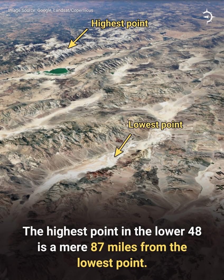
From ChatGPT:
People do attempt the full Badwater → Whitney summit route
A very small number of ultra-endurance athletes complete it each year.
It is considered one of the hardest human-powered climbs on Earth due to:
• A 14,700 ft vertical gain from the lowest to highest points in the lower 48
• Temperatures of 115–125°F in summer at Badwater
• 135+ miles of road to Whitney Portal
• An additional 22 miles round-trip from Portal to the summit
• Extreme dehydration and heat riskTotal: ~157 miles with the biggest continuous elevation gain in the continental U.S.
-
A buddy of mine is a big climber and has done 5 of the 7 summits including Everest. He did Mt Whitney once (with another friend of mine) but never thought to start at the basin.
-
Ah ok. Guess Ben Nevis ain't on his list then
 (though it gives a fine view for moderate effort and a classic ridge descent with golden eagles for company).
Kangchenjunga... respect, it has a kill rate of 1 in 5.
I recall the first up (Joe Brown?) stopped very slightly short of the summit out of respect to its divine status.
Hello! It looks like you're interested in this conversation, but you don't have an account yet.
Getting fed up of having to scroll through the same posts each visit? When you register for an account, you'll always come back to exactly where you were before, and choose to be notified of new replies (either via email, or push notification). You'll also be able to save bookmarks and upvote posts to show your appreciation to other community members.
With your input, this post could be even better 💗
Register Login