Skip to content
  • Categories
  • Recent
  • Tags
  • Popular
  • Users
  • Groups
Skins
  • Light
  • Brite
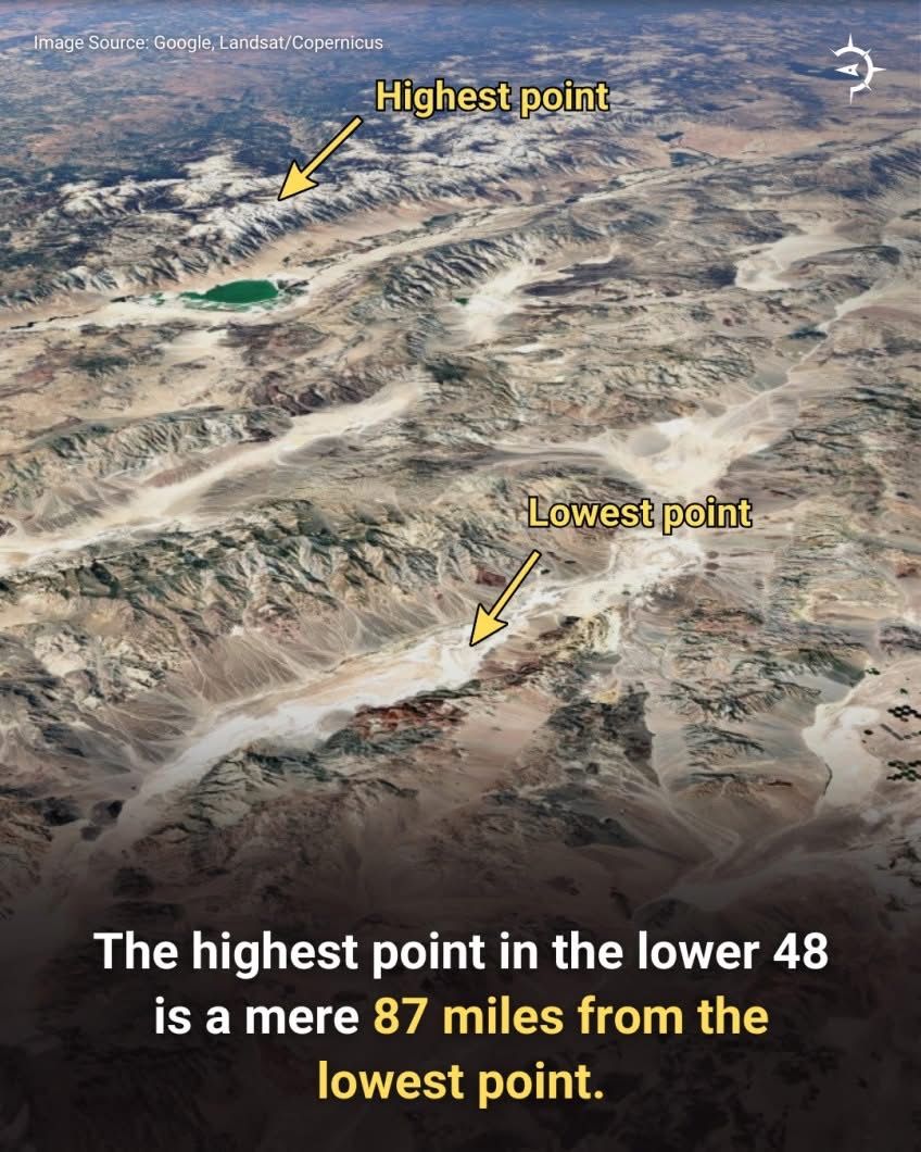
  • Cerulean
  • Cosmo
  • Flatly
  • Journal
  • Litera
  • Lumen
  • Lux
  • Materia
  • Minty
  • Morph
  • Pulse
  • Sandstone
  • Simplex
  • Sketchy
  • Spacelab
  • United
  • Yeti
  • Zephyr
  • Dark
  • Cyborg
  • Darkly
  • Quartz
  • Slate
  • Solar
  • Superhero
  • Vapor

  • Default (No Skin)
  • No Skin
Collapse
Brand Logo

WTF-Beta

  1. Home
  2. Categories
  3. Off Key - General Discussion
  4. How did I not know this?

How did I not know this?

Scheduled Pinned Locked Moved Off Key - General Discussion
13 Posts 5 Posters 72 Views
  • Oldest to Newest
  • Newest to Oldest
  • Most Votes
Reply
  • Reply as topic
Log in to reply
This topic has been deleted. Only users with topic management privileges can see it.
  • D Offline
    D Offline
    Daniel
    wrote last edited by Daniel
    #3

    There's a large difference between 0 and 999 ft. as any Floridian can tell you.

    Interesting.

    1 Reply Last reply
    • B Offline
      B Offline
      Bernard
      wrote last edited by
      #4

      The map doesn't go below sea level.

      The industrial revolution cheapened everything.

      wtgW 1 Reply Last reply
      • D Offline
        D Offline
        Daniel
        wrote last edited by Daniel
        #5

        Hawaii Island (a county) is listed as 13,000- 13,999 ft. This is radically incomplete and essentially worthless to the viewer.

        J 1 Reply Last reply
        • B Bernard

          The map doesn't go below sea level.

          wtgW Offline
          wtgW Offline
          wtg
          wrote last edited by wtg
          #6

          @Bernard said in How did I not know this?:

          The map doesn't go below sea level.

          I fixed my OP. I had copied/pasted their original heading, which said it represented highest/lowest. OTOH, according to the legend, the map actually just shows the highest elevation in each county (though they say country, which of course makes one wonder how accurate the map is to begin with!) If it really is highest....I can't think of any place where the highest elevation is below sea level.

          When the world wearies and society ceases to satisfy, there is always the garden - Minnie Aumônier

          D 1 Reply Last reply
          • D Daniel

            Hawaii Island (a county) is listed as 13,000- 13,999 ft. This is radically incomplete and essentially worthless to the viewer.

            J Offline
            J Offline
            jon-nyc
            wrote last edited by
            #7

            @Daniel said in How did I not know this?:

            Hawaii Island (a county) is listed as 13,000- 13,999 ft. This is radically incomplete and essentially worthless to the viewer.

            How? Mauna Kea is 13,796 according to wikipedia

            D 1 Reply Last reply
            • J jon-nyc

              @Daniel said in How did I not know this?:

              Hawaii Island (a county) is listed as 13,000- 13,999 ft. This is radically incomplete and essentially worthless to the viewer.

              How? Mauna Kea is 13,796 according to wikipedia

              D Offline
              D Offline
              Daniel
              wrote last edited by
              #8

              said in How did I not know this?:

              @Daniel said in How did I not know this?:

              Hawaii Island (a county) is listed as 13,000- 13,999 ft. This is radically incomplete and essentially worthless to the viewer.

              How? Mauna Kea is 13,796 according to wikipedia

              Because it starts at about 0- 10 ft.

              1 Reply Last reply
              • wtgW wtg

                @Bernard said in How did I not know this?:

                The map doesn't go below sea level.

                I fixed my OP. I had copied/pasted their original heading, which said it represented highest/lowest. OTOH, according to the legend, the map actually just shows the highest elevation in each county (though they say country, which of course makes one wonder how accurate the map is to begin with!) If it really is highest....I can't think of any place where the highest elevation is below sea level.

                D Offline
                D Offline
                Daniel
                wrote last edited by
                #9

                @wtg said in How did I not know this?:

                @Bernard said in How did I not know this?:

                The map doesn't go below sea level.

                I fixed my OP. I had copied/pasted their original heading, which said it represented highest/lowest. OTOH, according to the legend, the map actually just shows the highest elevation in each county (though they say country, which of course makes one wonder how accurate the map is to begin with!) If it really is highest....I can't think of any place where the highest elevation is below sea level.

                I see. They needed an edit.

                1 Reply Last reply
                • A Offline
                  A Offline
                  AndyD
                  wrote last edited by
                  #10

                  I'm guessing people hike from Badwater to Whitney peak just because? I'd like to do that.

                  Ventosa viri restabit

                  1 Reply Last reply
                  • J Offline
                    J Offline
                    jon-nyc
                    wrote last edited by
                    #11

                    From ChatGPT:

                    People do attempt the full Badwater → Whitney summit route

                    A very small number of ultra-endurance athletes complete it each year.
                    It is considered one of the hardest human-powered climbs on Earth due to:
                    • A 14,700 ft vertical gain from the lowest to highest points in the lower 48
                    • Temperatures of 115–125°F in summer at Badwater
                    • 135+ miles of road to Whitney Portal
                    • An additional 22 miles round-trip from Portal to the summit
                    • Extreme dehydration and heat risk

                    Total: ~157 miles with the biggest continuous elevation gain in the continental U.S.

                    1 Reply Last reply
                    • B Offline
                      B Offline
                      Bernard
                      wrote last edited by Bernard
                      #12

                      I was looking at a picture of Whitney and I wonder why 3 of the nearby minor summits have names with "Needle", but three have names with "Aiguille," which is French for needle.

                      The industrial revolution cheapened everything.

                      1 Reply Last reply
                      • J Offline
                        J Offline
                        jon-nyc
                        wrote last edited by
                        #13

                        A buddy of mine is a big climber and has done 5 of the 7 summits including Everest. He did Mt Whitney once (with another friend of mine) but never thought to start at the basin.

                        1 Reply Last reply
                        Reply
                        • Reply as topic
                        Log in to reply
                        • Oldest to Newest
                        • Newest to Oldest
                        • Most Votes


                        Powered by NodeBB | Contributors
                        • Login

                        • Don't have an account? Register

                        • Login or register to search.
                        • First post
                          Last post
                        0
                        • Categories
                        • Recent
                        • Tags
                        • Popular
                        • Users
                        • Groups